This is an extremely difficult race report to write. I was so looking forward to racing again and completing the WY Range 100, so to not finish is disappointing. But I know that I chose a challenging race that lived up to that description. Besides, I don’t do easy things, so failure (or should I be more positive and so not meeting my goals) is bound to happen. I did everything I could to finish, it just wasn’t in the cards for this race.
First, a bit about WY Range 100. I found out about this first-year race in early 2020 through Caleb, who is the High Lonesome RD, as well as the Buffalo Run RD, Jim Skaggs. They were both signed up for it, and it sounded amazing. 103 miles, with approximately 30k of climbing through the Bridger-Tetons, just south of Jackson Hole, WY, sounded just like my type of race. After Hellbender was cancelled, I signed up hoping that by August, the events of 2020 would be past. Boy, was I wrong. The race was on in early July, however, 2 weeks later, they canceled due to lack of key volunteers given the continued restrictions due to the pandemic. This was a remote race and having aid station volunteers who were experienced, is a critical factor. So, I decided to defer my entry to this year.
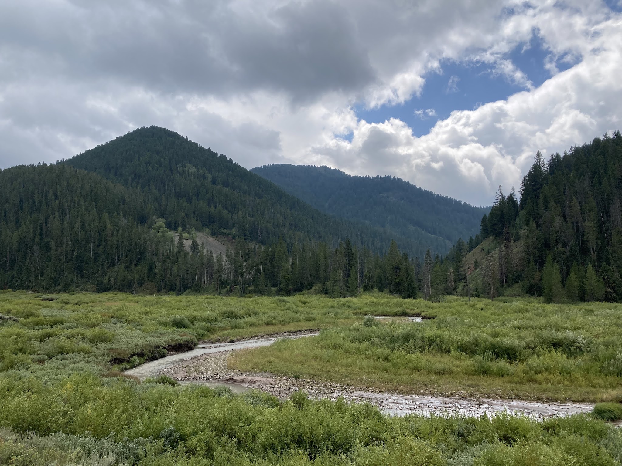
About the course itself: it is designed to be a point to point, starting at a trailhead west of Big Piney WY and finishes in Hoback, WY. The race runs along the WY Range National Trail, which unfortunately, isn’t traveled heavily. There were going to be areas where we’d be traveling flag to flag to find our way. In addition, it started at noon on the 20th, with only 2 cut-offs, 24 hours at the 53-mile point and 48 hours to the finish. I figured it was going to take me between 36-40 hours, but realistically closer to the 40 hours.
Fast forward a year…I had a couple of setbacks due to injuries in the fall and spring, but nothing that kept me out too long, just some niggles that I wanted to let heal. I put in some good training blocks over the summer, to include an overnight 50k sweep section at High Lonesome three weeks prior. The only stumble was that on the last big run, two weeks prior, I took a nasty fall and broke a finger. This was going to make the golf part of our vacation more challenging, as well as holding poles for climbing.
The RDs were very proactive in communications with us about the course. About 3 weeks prior, there was a fire that was close to the course, but they were working with the Forest Service. The fire grew bigger and some of the trails were closed, but the RDs, had a few different back-up courses ready to execute. Two weeks prior, the fire was contained and the FS authorized the original course. That was good news, since the reroute required about 17 miles of dirt road.
Mark and I had planned this to be our first vacation away from ‘home’ for a long time. Since buying the NC house, we’ve done most of our vacations there. While we had hoped that the 2019 High Lonesome trip would be a vacation, work commitments squeezed us to just going there and returning as soon as the race was over. This time, we’d spend a lot of time prior in Yellowstone, the Tetons and Pinedale, WY. We had a great time despite it being more a working vacation for me (and later him). The cabin I found in Pinedale was a gem, with all sorts of wildlife, to include moose, otter and eagles.
About a week out, I started looking at the weather to see what to pack in my dropbags. Smoke in the air from the fires in the west were going to be the biggest challenging in my opinion. However, the forecast started to show some storms on Sat night in addition to a cold front coming through on Wednesday. On Thursday evening, the RD sent out a note saying they were switching the low altitude course due to forecast on Friday morning of fog and rain, with below freezing temps at the higher portions of the course that were to the south. The low-altitude course was and out/back from the finish line in Hoback, which now made the course a ~98 mile out-back. It was still going to pack a wallop of climbing. That decision, while making my drop bags a bit easier, really set up the chain of events. Although, even if the full course had been used, I may have been stuck on the most exposed peak during the storm that came up Sat afternoon…
New course profile:
Although there was a long list of mandatory gear, to include bear spray, long sleeve shirts were not on the list. For some reason, I only packed one completely forgetting that there was a chance that I’d be out two nights in a row. Luckily, there was a really cool out-door store in Pinedale, so I was able to get a second to stash in a second dropbag. Due to the cooler temps, I actually started out wearing long sleeves, instead of just my armsleeves as I thought I would.
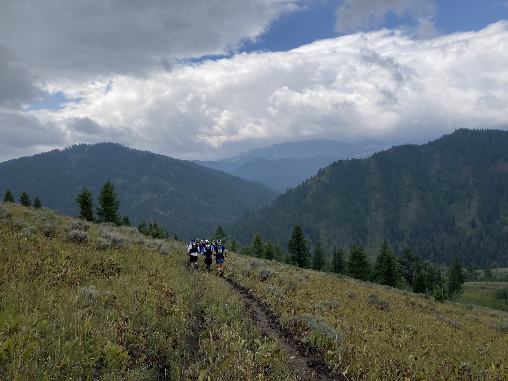
The race started out well, just very wet and mucky, especially since the trails are used by horses. The river crossings were flowing fast and high, but nothing too terrible or treacherous. I got into a comfortable rhythm and kept moving well. About 3 hours in, I got a message from Mark stating that I wasn’t tracking on the race’s webpage, so since I was using my personal in-Reach, I put it into tracking mode, so he could at least track me on my personal page. That seemed to work (we were originally told to just turn them on and didn’t need to track). Somewhere in this area, I missed a turn somewhere in this area and ended up on a wrong trail, it wouldn’t be the first time on this journey.

There were some spectacular views to be seen, so I tried to occasionally stop to take them in early in the race. Later, I was just too frustrated and behind on time to pull the camera out. Looking east was really clear of smoke, while to the west, it could be seen coming back. The trails themselves were in various shape. Some were well used, others not so much. Unfortunately, I found that the downs were hard to run in some cases due to loose rocks and dirt and the grade. My poor big toe is black from hitting the front of my shoes on the downs.


Getting into Hunting Camp, I was only about 30 mins behind my most optimistic pace. I was climbing well and taking it easy on the descents, but moving. Kelsey was the aid station captain and it was great to see her. Shortly after leaving, I came upon two ladies trying to figure out if we had to cross a stream, since it wasn't obvious to us. I pulled out my map and, yep, feet wet again…As we were now getting into darkness, I asked if they minded if I tagged along with them, so we became the 3 L’s…Lisa, Lara, and Lori. We’d stick together for the next 12 hours or so. We had a few other guys join us, for a bit as we navigated the treachery near Deadman’s peak.

It was in this section on the way to Deadman that things really got crazy. Since the trail was marked for one-way traffic, some of the markings were not in the right spot for runners coming the other direction. Nor were there confidence markings at turns that would have helped us. Coming from the ‘original’ direction, a runner might not have even noticed a side trail that forked into the main trail, but from our direction, it wasn’t always clear which direction to go. While I had three different maps that showed gpx data, it was slow going trying to figure out the correct direction. I always seemed to be paralleling the course, either to the right or left, but I couldn’t get the fidelity to say definitely until we started moving what way to go.
Then we arrived at the meadow…I swear this cost me three hours, but realistically, probably only two hours were lost, since it took me almost 6 hours to go the 10 miles between the aid stations, when it should have taken 4ish. I'm not sure this would have made a difference in the end result. We knew there wasn’t a cut trail in this section, but we were told to follow the course markings. The problem was that we couldn’t find them. We’d get to one, but the next wasn’t always in visual sight, even with, by now 6-8 of us shining lights across the field. It was also slow going due to the slick conditions and sagebrush. At one point, trying to go to a flag, I whacked my head hard into a tree branch that I didn’t see. Luckily my headlamp took the brunt of the impact, but it left me dazed for a few seconds. Just as we were almost out, someone came the opposite direction to put more flags down. Go figure... Looking at my gps track, I think we kept seeing flags out of order in the night and going to them
The climb to Deadman Peak was brutal and a bit scary in the dark. Luckily, we had a beautiful full moon. We grabbed our trinket, warmed up a bit in the dilapidated hut and made the slow descent back down to the main trail. We knew we’d have to return to this peak on the return trip, but hopefully it would be in the daylight. Again, this area wasn’t clearly marked, but we could make a general direction where we needed to go under the moonlight. (The full moon was spectacular, even if it was a bit red due to the smoke in the air)
Getting to Deadman’s aid station, we refueled and was told it was a relatively flat section…not. It started out as a gradual uphill FS road, but then transitioned to a steep odd trail that zigged and zagged. At one point we couldn’t figure out if we were criss-crossing our own trail. We made it to Blind Bull in just under 17 hours. While we were there, the leader came cruising in, taking little aid.

Leaving this aid station, it was still dark, but the sun was coming up. Again, we got lost, and added even more bonus miles since the marking was in an odd spot hat you couldn’t easily find. While it’s easy to say if you don’t see a marker after ¼ mile, it’s harder in real life to figure out if you’ve seen one, especially when you are on a well-used trail and the map shows you just to one side of the real trail, which was on the other side of a ridge! I was mentally frustrated at this time, but still moving well and pulled ahead of Lara and Lisa. Somewhere along here I slipped on some mud and went down on my broken finger. Not too hard, but it made me yelp. I came across Caleb, who was returning. While he seemed like he was doing fine, it turns out he pulled a hamstring somewhere in this section and ended up dropping at Blind Bull #2.
I cruised into McDougal just under 22 hours into the run. I was fine, and wanted to make it a quick turn knowing that I now had only 26 hours to finish. However, since I now had a sense for the course and the markings were in the correct position, I thought it would be doable. Tight but doable. I needed to keep moving and not waste too much time at aid stations. I ate, got some coffee, and gathered my things for the return trip.
I will say that the aid station workers all the way throughout were wonderful. Here one of the ladies was actually cleaning our feet for us. At Blind Bull, the couple in charge were celebrating their anniversary. Others had to hike in and spent a miserable Sat evening in the cold rain.

As I was getting ready to leave, Lara and Lisa came in. Lisa’s husband, John, had been there for a bit already and looked like he was going to head out. (he had been behind us, but missed the Deadman Peak turn, so would have to do it twice on the return trip). They were eating and discussing stopping at that point. I headed out to start the return trip. I set off at a fast hike since my tummy didn’t like the coffee and quesadilla that I had consumed. I fell to plan B on eating, which was a ProBar chew every 10-15 mins to keep calories in me. About 20 mins later, I started getting really sleepy. So, I found a nice log, set a 10 min alarm, and closed my eyes. Not sure I every actually slept, but I did feel better. Somewhere toward the end of this section, Lara (although I didn’t realize it) came cruising by me, telling me the others decided to call it. She was feeling good after getting some food and wanted to continue on. At Blind Bull #2, we’d join up again and head out together.
Leaving BB, I was feeling good again and even running. Till we crossed a ridge and saw the storm over Deadman’s Peak, with lightning starting all around us. We knew there was a forested section but were not sure how far we were from it. However, at that time, we needed to get low and out of the exposed section immediately. Into the sagebrush we dove. I then used the inReach to text Mark and try to figure out what was going on. He informed me that the current cell was moving fast, but there were more behind it. When that cell passed, Lara and I decided to return to Blind Bull to figure out our next move, as the cold rain wasn’t pleasant. Unfortunately, this meant cutting into the precious padding on the cut-off. We trooped back to the aid station, and I continued to communicate with Mark. He informed me that there was a weather advisory till 10 pm, with winds up to 50 and possible hail. That did it for me. I didn’t want to be on exposed ridgelines during that and at night. Meanwhile the next wave of storms started. Mark later told me that the radar picture showed purples…
With that, we called it a day. The aid station folks were so helpful, pulling out puffy jackets and getting us warm. There were only a few other runners coming back from the turn-around, so we waited for a bit, then got into a truck for the almost 2 hour drive back to the start line. The RD was glad to see us and that we had made the right decision, he was pulling people from the later aid stations and stopping the race in places. I was just glad that I wasn’t on Deadman’s peak or any of the ridges at that time.

So, I took my first DNF (Did Not Finish). However, I know that it was a Did Nothing Fatal. In some ways, maybe the fact that it took so much longer than I anticipated, was a blessing in disguise. Had I been three hours faster, I may have been on Deadman’s Peak when the storm came up. I’m still a bit emotionally raw right now, even a week later. However, I read this great article from Brad Stulberg on how caring about something means risking being vulnerable (
The Cost of Caring). I put it all out there. Even when I was at my lowest, I didn’t want to quit and was moving with the goal of finishing. Had the weather not moved in, I may have finished, it would have been close to the 48-hour cut-off. In the end, I made the right decision. I’d eventually like to go back and try this course again, but I think it will be a few years, as I have other races that I want to do first.
Now to figure out what’s next…


No comments:
Post a Comment